|
Study Overview
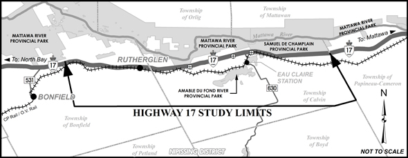
The Ontario Ministry of Transportation has retained AECOM to undertake a Class Environmental Assessment to identify a recommended plan for a four-lane Highway 17 within the study limits with access restricted to interchange locations. The study will develop and evaluate a range of reasonable alternatives, including improvements to the existing highway, new highway routes and / or combinations of the two. The study limits are shown on the key plan.
Highway 17 traverses northern Ontario, providing a strategic link in the Trans-Canada Highway. Besides providing for basic travel needs for residents as well as visitors to the area, this section of Highway 17 provides a transportation corridor for long haul trucks from eastern Canada to northern Ontario and western Canada.
External agency and public consultation will take place throughout the study, including three Public Information Centres (PICs). The PICs will provide the public and interest groups an opportunity to discuss the study with members of the project team and to provide comments. The first PIC is planned for late fall 2012 and will provide the public with an opportunity to review the draft Study Design Report (SDR), preliminary route alternatives and the proposed evaluation criteria. Notices providing the time and location of the PICs will be posted on the project website www.highway17routeplanning.ca, published in local newspapers and sent to persons on the project mailing list.
|
|
|
|